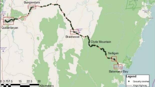
A 132-kilometre stretch of highway connects Queanbeyan to Batemans Bay. Knowing where its blackspots are may help you make it to the end.
Subscribe now for unlimited access.
$0/
(min cost $0)
or signup to continue reading

Highway patrol officers will begin a blitz of the Kings Highway this week as waves of Canberrans roll down the coast for summer, but researchers have shed light on where, when and why people are likely to crash on the road.
Sahar Alian co-authored a paper on the Kings Highway which was presented to the Australasian Road Safety Conference earlier this year, and said road geometry, time and direction of travel and driver behaviour all interact to influence crashes on the road.
"In general the risk of having a crash is higher at night. But crash rates are higher during the day travelling eastbound down the coast probably due to the stronger effect of road geometry [the combination of curvature and vertical grade] on driver behaviour travelling eastbound," she said.
The biggest crash clusters are located in the first five, windy kilometres of the Clyde Mountain area travelling eastbound. Mrs Alian said most of these crashes occur during the day.
The researchers homed in on driver behaviour in this area in particular, especially in the way the road geometry impacted the crash rate.
They found while the high rate of night crashes may be written off as speed, the lack of visual field or driver experience, the daytime results means the road geometry may have a stronger influence.
They unequivocally found you were more likely to crash during the day if you were heading eastbound, downhill.
Mrs Alian said further study will be required to fully explore the driver's role in crashes in this particular area.
All in all, they found there was a crash rate of 2.45 cars for every 100,000 motor vehicles which travelled on the Kings Highway in a 24-hour period between the years 2007 and 2011.
The mean age of the driver involved was 40 years and the majority were male, however the age plunged to a mean of 33 years at night.
The crash rate also rose to 3.25 crashes per 100,000 motor vehicles during the 12-hour evening period.
The researchers chose to focus on Kings Highway as it bucked the trend in terms of road casualties.
While casualty rates on Australian roads decreased in the decade leading up to 2010, a 2013 review by NSW Transport found casualties actually rose on the Kings Highway between 2009 and 2011.
Research undertaken by the NRMA in 2005 found the Kings Highway had an average of one crash every four days over the period of a decade.
Since 2011, the NSW state government has invested more than $62.5 million in safety upgrades on the Kings Highway upgrades.
The researchers suggested road authorities look at implementing variable speed limits along the road.
President of the Australasian College of Road Safety and Bungendore resident Lauchlan McIntosh said those efforts to "cut out a lot of blackspots" aren't reflected in this dataset due to its age.
But he believed it was a useful analysis of where money can be better invested along the highway to reduce hazards.
"Quite often we take crashes as the only indicator of where the road is bad and that may not be the case, we may have a lot of near-misses," Mr McIntosh said.
"You've got to take as much data as you can and see what you can do to avoid the crash. It's a welcome paper and it should help if people take the data and reduce the hazards on the highway."
- The Canberra Times

